
價格:免費
更新日期:2019-10-25
檔案大小:64M
目前版本:2.0.54
版本需求:Android 4.0.3 以上版本
官方網站:http://www.ihunterapp.com
Email:info@ihunterapp.com
聯絡地址:408 Ranch Estates Pl NW Calgary, AB T3G1L9 Canada
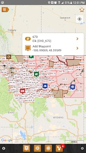
iHunter Montana gives hunters and outdoor enthusiasts a new view into Montana's many different hunt areas. By overlaying the Hunt Areas on top of the built in maps, users can see their current location and which Hunt Area they are in. Dive deeper into specific areas to see which big game, predator, and game bird seasons are open. Contribute to the map by adding your own waypoints to keep track of hunting spots, past animal harvests, and landowner contact information.
Features:
- Includes regulation summary for the current season (free updates every year, works offline)
- View Deer, Elk, Antelope, Bear, Goat, Moose, Mountain Lion, Sheep, Turkey, Wolf, Bison and Trapping Areas on top of built in maps (Hunt Areas display offline)
- Select Hunt Areas to view summary of open seasons (works offline)
- 7 different base map types, including 4 that can be cached for offline use
- Add waypoints to the map at your current location, known GPS locations or where you tap and hold (works offline)

- Edit the name, description, image and location of your waypoints (works offline)
- Store Landowner contact information in waypoints to keep track of all your hunting contacts in one place (works offline)
- Send your friends or family an email or text message with your current location so they can easily find you (requires internet to send email)
- Use the sunrise / sunset calculator to look up legal hunting light at your location or waypoint location (works offline)
- Share waypoints via email to friends and hunting partners (requires internet to share waypoints)
- Quick dial button for the Turn-In-Poachers tip line
- Indian Reserve boundary layer (works offline)

- FWP Owned Lands boundary layer (works offline)
- Chat with other users
- Share waypoints, current location, and your live location
Pro Tools In-app purchase (one time fee):
- Track your position as you hunt - get an altitude and velocity profile as well as a track overlaid on the map
- Draw over the map to highlight property lines, animal patterns, or trails
- Search the map for businesses or points of interest (internet connection required)

- Recently viewed and favorites lists for Hunt Areas and waypoints
